
Avalanche Problem Web Series:
Part 7 – Loose Wet
How to Apply the Avalanche Forecast to Your Riding
For splitboarders venturing into the backcountry, information can be the difference between an epic day and tragedy. In an effort to increase education and avalanche awareness, Spark R&D is presenting a 7-part web series called Avalanche Problems, which will explain the nationally standardized types of slides most commonly described in advisories by avalanche forecasters.
Understanding the characteristics of each type will help to determine where avalanches are likely to occur and what kind of terrain should be avoided. In today’s final installment, we will cover Loose Wet Avalanches.
Loose wet in a nutshell
 Late in the season is often the time to go big, as the snowpack is generally more stable and predictable. But when the temperature rises during the day, the upper layer of the snowpack turns to slush and peels away from the mountain, much like a wet sluff. Get an early start, retreat when it gets hot or the slush becomes deeper than ankle height, and be weary when nighttime temps do not dip below freezing.
What exactly is a loose wet avalanche?
• Above freezing temperatures and/or rain cause the surface to lose cohesion, and give way in a loose snow avalanche. Because of the water in the snowpack, these carry more mass, and have the potential to pack quite the punch.
• This is caused by either new spring snow, which is peeling off the underlying surface, or from frozen corn snow has thawed and turned to slush.
• This is often a springtime problem, as temperatures generally stay cold enough mid-winter.
• When temperatures cool off enough for the snowpack to re-freeze, than the problem will subside. When temperatures warm back up, the problem could come back.
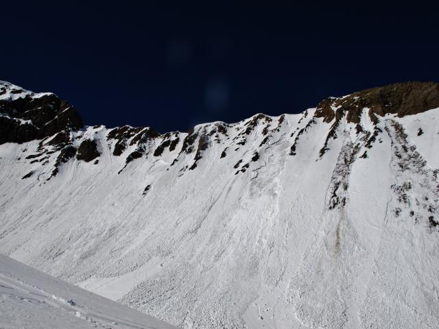
Where might you find loose wet conditions, and how to avoid it
• When wet slides occur, they tend to be fairly widespread.
• The timing can vary throughout the day. Slopes facing easterly (NE, E, SE) get first sun. ![]()
![]() Southerly slopes are late morning and mid day (SE, S, SW), and westerly slopes get the afternoon heat (S, SW, W, NW, N). Try to follow the pattern of the sun.
Southerly slopes are late morning and mid day (SE, S, SW), and westerly slopes get the afternoon heat (S, SW, W, NW, N). Try to follow the pattern of the sun.
• Once the snow becomes too soft, stay off of steep terrain and avoid travelling below known avalanche paths.
• Similar to “loose dry” avalanches, think not only about being buried, but also about the consequences of being carried into terrain features, like cliffs, rocks, and trees.
• Rocks can intensify the heat, so be extra cautions as wet slides can initiate around them. In warm weather, be watchful for rock fall, too.
• If working with corn snow (frozen surface late in spring), the best riding can be had when just the top couple inches have thawed. This means the probability of wet avalanches is less likely, and the snow is not too heavy, deep and cumbersome for riding.
• Think not only of triggering slides, but naturals too. It’s very common to have natural activity with wet avalanches, so watch above on big slopes.
How to look and test for loose wet conditions
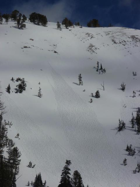
Photos courtesy of Gallatin National Forest Avalanche Center (mtavalanche.com).
• Wet surface conditions can be observed without any kind of snowpack test or formal pit.
• Warning signs can start to appear: Intense sun; above freezing temperatures; roller balls peeling away and running down slope; gloppy, wet or mushy surface conditions; and natural avalanches.
• Paying attention to the weather history and the current weather conditions provide valuable clues. Many warm days with a very light freeze (just below 32) or no freeze at night means the snowpack is not getting time to re-strengthen, and can be especially tender when the sun comes out.
• Cold and clear nights will yield the best freeze and will give you the most time to work with during the day.
Tips: In the springtime, don’t be afraid to get pre-dawn starts to beat the heat. If you’re too early and the conditions are dangerously firm, than you can always wait for the surface to soften. Remember the conditions can change very quickly, with low hazard in the morning, and high hazard once the heat turns on.
Disclaimer: Although characteristic, these descriptions are general, so make sure to read into any specifics mentioned on your local advisory. Also, this is just one piece of the puzzle, so remember to factor in the hazard rating and any field observations.
Find your local avalanche center: www.avalanche.org
Thanks for joining us for our 7-part web series discussing the most common avalanche problems used by forecasters. By learning about each problem, we can become familiar with the duration, terrain management and how to look for these problems.
Before heading out the door in the AM, we recommend checking the avalanche bulletin, weather forecast, and thinking about any relevant field observations. Think about where the problem may reside, and spend a little time considering what terrain might be no-go and what terrain would be attainable.
A big shout-out to the Gallatin (Bozeman), Sawtooth (Ketchum) and Colorado Avalanche centers for their collaboration and use of images!
Presented by Clark Corey
Splitboard Guide/Avalanche Educator